Menu
Menu
![]()
The Tahoe Rim Trail (TRTA) offers training, courses, programs, special events, and more designed to help educate the general public and promote access to the Tahoe Rim Trail system. Learn to backpack, find information on guided hikes, or get information on how to volunteer!
Hiking in Tahoe is one thing but if you've wanted to try backpacking but weren't quite sure how to get started then please join the TRTA for our Backpacking 101 class. Led by our seasoned guides and stellar Snowcamping 101 instructors, this class will go over all the basics of backpacking from what to bring and how to pack to choosing a campsite and cooking your meals.
Our Horseback Trail coverage includes Bayview Trail, Big Meadows to Kingsbury, Brockway Summit to Tahoe City, Carson Pass to Highway 50, Meeks Bay Trail, Spooner Summit to Kingsbury, Spooner Summit to Tunnel Creek, and some Horseback Camping Tips. You will find information on horseback riding stables and boarding facilities in Tahoe's Best 'Places to Go' guide.
Hungry for more? We offer Backpacking Equipment Tips, Backcountry Safety Tips and tell you what to do if you meet up with a Black Bear! And for those extreme hikers we offer complete coverage of Desolation Wilderness, Granite Chief Wilderness, Mokelumne Wilderness, Mount Rose Wilderness, Emerald Bay Area, Fallen Leaf Lake Area, and the Meiss Country Area plus a list of who to contact for more information.
 You will also find many informative maps right out of the pages of our favorite trail book, rendered as scalable pdf files.
That's just the beginning. Hiking in Lake Tahoe is part of Lake Tahoe's biggest online information source - Tahoe's Best.
List of Popular Hikes and Hiking Trails in Lake Tahoe
Miles of seemingly untouched wilderness, pristine waterfalls, alpine lakes, wildflowers, rock formations, and views, views and more views… those are just a few ways to describe hiking in beautiful blue Lake Tahoe. From easy family hiking trails in Tahoe Donner, to the network of easy to moderate trails in Sugar Pine Point and Desolation Wilderness, to Angora Lake and the Echo Lakes trail system near South Lake Tahoe, hiking in Tahoe is epic, aweinspiring (Mt. Tallac), stunning (gotta love the granite facing cliffs on the hike from the base of Squaw to Shirley Lake and up to High Camp…), magnificent (Mt. Rose), breathtaking (anything overlooking Emerald Bay…), astonishing and yes, if you are looking for it, sometime daunting.
Check out this sample list of great hiking trails in Lake Tahoe and for an even longer list, see our Tahoe hiking trails by Region section.
North Lake Tahoe & West Shore Hiking Trails
High Camp at Squaw Valley
-
Rating: Easy to Moderate
-
Distance: Varies – multiple trails
Trailhead Location: Take Cable Car up from base at Squaw Valley and access multiple hikes out of High Camp. Alternatively, you can hike up from the base at Squaw to Shirley Lake which is a beautiful 2.5 mile hike or 4 miles to High Camp.
Five Lakes
-
Rating: Moderate to Middle of the Road
-
Distance: 5 miles
Trailhead Location: Multiple but easy access off Alpine Meadows Road about ½ up on right side. Park on road.
Marlette Lake
-
Rating: Moderate
-
Distance: 5 miles
-
Trailhead Location: Lake Tahoe Nevada State Park
Mt. Rose Trail
-
Rating: Difficult
-
Distance: 6 miles
-
Trailhead Location: Near Meeks Bay Resort
Tahoe Rim Trail North
-
Rating: Moderate to Difficult
-
Distance: 5 miles
-
Trailhead Location: Highway 50 east, signs pointing to trail
Page Meadows
-
Rating: Easy
-
Distance: Varies on different trails
-
Trailhead Location: Pineland Dr off Hwy 89
Stateline Lookout
-
Rating: Easy
-
Distance: Less than a mile
-
Trailhead Location: Lake Shore Avenue, park in lot underneath the lookout
Sugar Pine Point State Park
-
Rating: Easy to Difficult
-
Distance: Varies
-
Trailhead Location: About 10 miles south of Tahoe City, signs directing you to the park
More great hikes in North Lake Tahoe & the West Shore of Lake Tahoe:
-
Martis Creek
-
Meeks Bay Trail
-
Northstar
-
Rubicon Trail
-
Shirley Canyon
South Shore Lake Tahoe Hiking Trails
Mount Tallac
-
Rating: Difficult
-
Distance: Just under 10 miles
-
Trailhead Location: Highway 89, 3.5 miles north of South Lake Tahoe on the left
Angora Lake
-
Rating: Difficult, Uphill
-
Distance: About 3.5 miles
-
Trailhead Location: Fallen Leaf Lake Rd
Moraine Trail
-
Rating: Easy
-
Distance: 1 mile
-
Trailhead Location: Fallen Leaf Lake Rd
Glen Alpine Trail
-
Rating: Various trails ranging from easy to difficult
-
Distance: 2+ miles
-
Trailhead Location: Fallen Leaf Lake Rd
Echo Lakes Trail
-
Rating: Various trails ranging from easy to difficult
-
Distance: 2.5 – 9 miles
-
Trailhead Location: Hwy 50 to Johnson Pass Rd. Parking near Lower Echo Lake
More great hikes in South Lake Tahoe:
-
Freel Peak
-
Lake Aloha
-
Clark Trail
Southern Part of West Shore Hiking Trails and Trail Systems
Bayview Trail
-
Rating: Difficult to Challenging
-
Distance: Varies
-
Trailhead Location: Highway 89 So. starting in Tahoe City – go roughly 20 mi. to Bayview Campground. Parking available in campground.
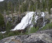
Desolation Wilderness
-
Rating: Multiple trails range from Easy to Difficult.
-
Distance: Varies
-
Trailhead Location: Multiple. One popular trailhead is by Lower Echo Lake
Cascade Creek Fall Trail
-
Rating: Easy
-
Distance: 1 mile
-
Trailhead Location: Highway 89 So. starting in Tahoe City – go roughly 20 mi. to Bayview Campground. Parking available in campground.
Truckee/Donner
Glenshire Lake Loop
-
Rating: Easy, Great for families and kids
-
Distance: 1 mile loop with beautiful mountain views
-
Trailhead Location: Behind Glenshire Clubhouse
Castle Peak
-
Rating: Moderate
-
Distance: 3.5 miles
-
Trailhead Location: Donner Summit at Castle Peak
The Nature Trail
-
Rating: Easy family hike
-
Distance: 1 mile
-
Trailhead Location: Donner Memorial State Park
More great hikes in Truckee & Donner:
-
Donner Trail System
-
Mt. Judah & Donner Peak
-
Negro Canyon Overlook