Menu
Menu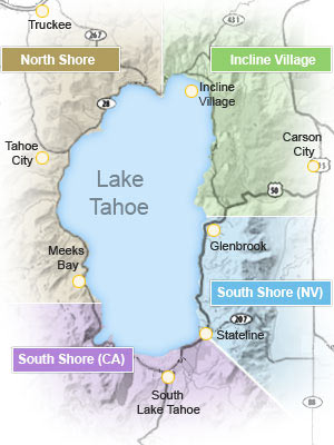

Detailed Map of Lake Tahoe
The following map of Lake Tahoe gives you a general idea of the highways directly around Lake Tahoe as well as where majority of Lake Tahoe golf courses, Tahoe casinos, airports, parks & attractions and ski resorts (the names are in bold, blue text on the map) are. You will notice that the majority of Lake Tahoe ski resorts, golf courses and casinos are on the north shore & south shore while there are plenty of parks on all shores - north, south, west and the sparsely populted east shore.
When deciding where to stay in Lake Tahoe, keep in mind that North Lake Tahoe has an older, classic "Tahoe feel" with many vacation rentals, cabins and lodges. The casinos in Incline Village and Crystal Bay NV also offer a more "mountain feel" right on the shores of Lake Tahoe. On the other hand, South Lake Tahoe is more centralized around Stateline NV with more of a "modern feel", stores, shops and a cluster of casino hotels adjacent to each other.
Getting to Lake Tahoe - Tahoe Highway Map and Road Maps
How to get to Lake Tahoe - There are four main routes into Lake Tahoe:
- From Reno to South Lake Tahoe: Take I-580 S/US-395 S from Reno, NV and the Reno–Tahoe International Airport to Carson City, NV, then US-50 W to South Lake Tahoe (61.5 miles; 1 h 20 min).
- From Reno to North Lake Tahoe: Take I-580 S from Reno, NV and the Reno–Tahoe International Airport to NV-431 W to Incline Village, NV (37.4 miles; 51 min). Alt Route: I-80 W to Truckee, then CA-89 S to Tahoe City (50.5 miles; 1 h) or CA-267 E to Kings Beach (42.6 miles; 49 min).
- From Sacramento to South Lake Tahoe: Take US-50 E to South Lake Tahoe (103 miles; 1 h 58 min).
- From Sacramento to North Lake Tahoe: Take I-80 E to Truckee, then CA-89 S to Tahoe City (117 miles; 2 h 5 min).
Where is Lake Tahoe? Lake Tahoe is split down the middle sharing California's eastern border with Nevada's western border. From the Reno-Tahoe Intl Airport it is 42 mi to Lake Tahoe (CA) and 34 mi to Lake Tahoe (NV). From Sacramento Intl Airport it is 114.4 mi, 2 h 6 min to South Lake Tahoe (CA) and 126.1 mi, 2 h 13 min to North Lake Tahoe (NV) at Incline Village.
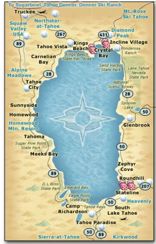
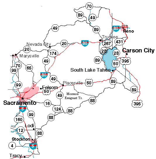
The map below is a basic area highway map, zoomed out to show driving routes from the SF Bay Area, LA, Sacramento, Carson City, and Reno to Lake Tahoe. You can see the various highways you can take to reach al points Lake Tahoe as well as which ones will get you to South Lake Tahoe and the ones that will guide you towards Truckee and the North Shore including Tahoe City, Kings Beach and Incline Village (NV).
On the map below you can see that Reno is situated just a little northeast of Lake Tahoe. Reno boasts the Reno-Tahoe International Airport (RNO), the closest (just 42 mi to the North Shore and 58 mi to the South Shore) and easiest airport to fly into when visiting Lake Tahoe. If you are flying in to the Reno-Tahoe Intl Aiport you can easily rent a car, coordinate a shuttle or pre-schedule a local friendly Tahoe taxi which are very fast, convenient and priced right (many also have vans for your mountain toys). If you are driving to Lake Tahoe the regional highway map below shows the highways from Reno, Carson City, and Sacramento... from the Bay Area you take I-80 to Sacramento and from LA you head north to Sacramento on I-5.
More Useful Tahoe Maps
The following set of links will give you their respective area maps and city maps. Use these to help you plan your trip to Lake Tahoe and give you a better idea of what each city has to offer!
North America Map
Western United States Map
Regional State Map
State Highway Map
Local Highway Map
Lake Highway Map
Below are a couple maps for the Tahoe Rim Trail, which is also a part of the Pacific Crest Trail extending from Mexico to the Canadian border. The Tahoe Rim Trail is not recommended for beginners, but for seasoned hikers. Anyone who is a veteran of long backpacking adventures will find the Tahoe Rime Trail to be not only a challenge, but an unforgettable experience!
The following maps are individual city maps for the towns and and cities around Lake Tahoe and the surrounding areas. Once you have figured out where you want to stay and what areas of Tahoe you wish to visit, use these maps to guide you around each town. Some maps are larger than others and might be easier referenced online versus being printed out.
Incline Village
Kings Beach
Lake Tahoe
Reno w/Downtown Insert
Reno/Sparks
Reno/Tahoe w/Mileage
Tahoe City
Truckee
U.S. Forest Service - Wilderness Areas