|


| |
Trails by Region
Weather conditions can change rapidly. Be prepared with the proper clothing and
equipment, no matter how short the hike. Backcountry users need to obtain a WILDERNESS
PERMIT for any hike into Desolation Wilderness. Day hikers may obtain a permit at the
self-service stations located at the trailheads. Overnight users must obtain a permit and
pay fees in person from the Forest Service office or Visitor Center.
Three types of fees will be tested in the Desolation Wilderness: a wilderness
permit reservation fee ($5.00), a overnight wilderness camping fee ($5/per person/per
night w/3rd night free or $30.00 individual annual pass), and a parking fee at Eagle Falls
Parking lot ($3.00 / per day / per vehicle or $20.00 / annual pass).
If you bring a pet on the trail, put it on a leash to minimize its impact on
wildlife and other visitors. Observe common courtesy and follow trail regulations. Other
hikers will appreciate your observance of minimum impact camping and packing out what you
pack in. REMEMBER...open campfires are NOT allowed in Desolation Wilderness!
North & East Shore Trails
- State Lookout
- Difficulty: Easy
- Elevation: 7,017'
- Mileage (one-way): ½ miles
- From Highway 28 on the north shore of Lake Tahoe, turn north on Reservoir Drive, just
east of the old Tahoe Biltmore Casino. Turn right on Lakeshore Avenue and left on Forest
Service Road 1601 (by the iron pipe gate). Park in the parking lot just below the lookout.
- During the summer the lookout is staffed with knowledgeable volunteers. Superb views of
the lake can be seen through the free telescopes located here. A short self-guided nature
trail, located by the lookout, explains the history of the north shore of Lake Tahoe.
- Prey Meadows / Skunk Harbor
- Difficulty: Easy
- Elevation: 6,200'/6,800'
- Mileage (one-way): 1½ miles
- Take Highway 28 from Highway 50 north approximately 2 miles. Look for an iron pope gate
on the west side of the highway. Park in one of the turnouts along the highway and do not
block the gate.
- Snow free in early spring, this is a great walk through a mixed conifer forest with
filtered views of Lake Tahoe along the way. Look for the remains of an old railroad grade
along the way, built in the 1870's as part of the network to supply timber to Virginia
City. When you reach a fork in the road, you have two options. The left fork leads to Prey
Meadows which is blanketed with many varieties of wildflowers in the spring. The right
fork leads you to Skunk Harbor, a small picturesque cove which offers great swimming and
sunbathing in the summer.
- Marlette Lake
- Difficulty: Moderate
- Elevation: 7,000'/8,000'
- Mileage (one-way): 5 miles
- Park at the Spooner Lake Trailhead, located in Lake Tahoe Nevada State Park, just
north/west of the Highway 50/28 junction. A parking fee is charged. Dogs are allowed on
leash.
- A moderate five mile uphill hike leads you through picturesque North Canyon, lined with
aspens, to Marlette Lake Dam. No fishing is allowed a Marlette Lake because it is a fish
hatchery.
- Rim Trail - North
- Difficulty: Moderate
- Elevation: 7,000'/8,600'
- Mileage (one-way): 5 miles to Marlette Lake, 13 miles to Tunnel Creek
- Take Highway 50 east approximately ½ mile from the junction of Highway 50 and 28.
Parking is located just beyond the summit along the north side of the highway.
- This trail provides wonderful views of the Carson Valley as well as glimpses of Lake
Tahoe along a forested trail. Just before Snow Peak, the trail forks. The left fork leads
you down steep switchbacks to the road to Marlette Lake. The right fork eventually leads
you to Tunnel Creek Road.
- Rim Trail - South
- Difficulty: Moderate
- Elevation: 8,560'/8,800'
- Mileage (one-way): 2 miles to Duane Bliss Peak, 3 miles to South Camp Peak, 4
miles to Genoa Peak, 12 miles to Highway 207 (Kingsbury Grade)
- Park at the Spooner Summit Rest Area located along Highway 50.
- The trail begins behind the Nevada Department of Transportation building. Several Views
of the Carson Valley as well as glimpses of Lake Tahoe can be seen along this forested
trail. It is possible to climb Duane Bliss Peak (8,658'), South Camp Peak (8,866') or
Genoa Peak (9,150') by traversing cross country.
- Mt. Rose
- Difficulty: Strenuous
- Elevation: 8,700'/10,778'
- Mileage (one-way): 6 miles
- Take Highway 431 (Mt. Rose Hwy.) north of Incline Village. Park at the trailhead located
one mile south of the summit.
- Mt. Rose (10,778'), one of the highest peaks near Lake Tahoe, offers excellent views of
the lake, the city of Reno and the surrounding area. Follow a dirt road for three miles
through a Lodgepole cloaked forest interspersed with mule ears and sagebrush. In the
spring, a lush meadow at the halfway point is filled with lupine, paintbrush and larkspur.
The last two miles follow slippery switchbacks to the ridge line. Write your name in the
log book located at the summit to show the world you made it!
South Shore Trails
- Moraine Trail
- Difficulty: Easy
- Elevation: 6,360'/6,410'
- Mileage (one-way): 1 mile
- Stroll along a relatively flat trail through the forest and along the shore of
picturesque Fallen Leaf Lake. Take Highway 89 north approximately 3 miles from South Lake
Tahoe to Fallen Leaf Road. Continue approximately 2/3 of a mile to Fallen Leaf Campground.
Drive through the campground and park just before campsite #75 on the right. There is no
fee for day use. Look for the trailhead sign near the parking area. In the winter, when
the campground is closed, you must park just beyond Fallen Leaf Campground off of Fallen
Leaf Lake Road and walk to the trailhead.
- Angora Lakes Trail
- Difficulty: Easy
- Elevation: 7,200'/7,470'
- Mileage (one-way): ½ mile to Angora Lakes
- An easy ½ mile hike leads to two lakes framed by cliffs. Swimming and fishing are
popular activities. Summers are crowded, so arrive early. Dogs must be on a leash at all
times. Take Highway 89 north approximately 3 miles from South Lake Tahoe to Fallen Leaf
Lake Road and turn left. Turn left at the first paved road. Continue to Forest Service
Road 12N14 and turn right. Watch for bicyclists along this road. Continue past Angora
Lookout to the road's end at the parking lot.
- Tallac Historic Site
- Difficulty: Easy
- Elevation: Flat
- Mileage (one-way): .3 mile on Lake of the Sky Trail
- Step back into the past and explore the personalities, events and summer homes of
turn-of-the-century Tahoe landowners. The trail begins from the Kiva Picnic Area and is
accessible to persons with disabilities. The site can also be reached from the Lake of the
Sky Trail that begins at the Lake Tahoe Visitor Center.
- Echo Lakes Trail
- Difficulty: Moderate
- Elevation: 7,420'/8,430'
- Mileage (one-way): 2½ miles to NW corner of Upper Echo, 4 miles to Tamarack, 5
miles to Lucille and Margery, 5 miles to Lake of the Woods, 6 miles to Aloha
- See a variety of alpine lakes on this moderate trail. Take Highway 50 to Echo Summit and
turn onto Johnson Pass Road. Stay left and the road will lead you to the parking area by
Lower Echo Lake. For a short walk, hike to the far end of Upper Echo Lake. A longer hike
leads you to one of the many lakes farther down the trail. A boat taxi operated in the
summer by Echo Lakes Resort cuts three miles off your trip. A nominal fee is charged for
this service. A wilderness permit is required.
- Glen Alpine Trail
- Difficulty: Moderate to Strenuous
- Elevation: 6,560'/9,735'
- Mileage (one-way): 2 miles to Grass Lake, 4 miles to Susie, 5 miles to Heather, 6
miles to Aloha, 4½ miles to Half Moon, 5½ miles to Alta Morris, 6 miles to Tallac
(strenuous)
- Many different hikes can be taken from this trailhead. For a short walk, try the 2 mile
hike to Grass Lake. Another hike to Lake Aloha leads you past a small waterfall, a
beautiful meadow and three alpine lakes. A third option is a moderate hike to Half Moon,
Alta Morris or Gilmore lakes. If Mt. Tallac is your goal, the Glen Alpine Trail offers a
more moderate approach. Take Highway 89 north approximately 3 miles from South Lake Tahoe
to Fallen Leaf Lake Road. Watch for bicyclists and other cars on this narrow, one-lane
road. Continue until you see the Glen Alpine trailhead sign and turn left. Trailhead
parking is across from Lily Lake. A wilderness permit is required.
- Clark Trail
- Difficulty: Strenuous
- Elevation: 6,420'/7,470'
- Mileage (one-way): 1.6 miles to Upper Angora
- For the more adventurous, this strenuous hike can provide some solitude. Traversing
through loose shale up a steep grade, the trail ends at Angora Lakes. Take Highway 89
north from South Lake Tahoe to Fallen Leaf Lake Road. Parking is located at the Glen
Alpine Trailhead described in the previous hike. From the parking area, walk back down the
road to the junction of Fallen leaf Lake Road. Look for the small church to your right. A
little post located behind the church marks the hard-to-find trailhead.
- Mt. Tallac Trail
- Difficulty: Strenuous
- Elevation: 6,480'/9,735'
- Mileage (one-way): 1.7 miles to Floating Isle, 2½ miles to Cathedral, 5 miles to
Tallac
- Providing a spectacular view of Fallen Leaf Lake, Lake Tahoe and Desolation Wilderness,
this strenuous hike is well worth the effort. The first part of the trail to Floating
Island and Cathedral lakes is moderate and can be enjoyed by the novice hiker. Beyond
Cathedral Lake, the trail becomes steep and strenuous as it continues up the front face of
Mt. Tallac. The trailhead is located approximately 3½ miles north of South Lake Tahoe on
Highway 89. Look for the Mt. Tallac Trailhead sign directly across from the entrance to
Baldwin Beach and turn left down the dirt road. Continue to the trailhead parking. Weather
conditions can change rapidly in the Sierra mountains; bring a jacket, carry lots of water
and allow plenty of time for your trip. A wilderness permit is required.
West Shore Trails
- Cascade Creek Falls
- Difficulty: Easy
- Elevation: 6,800'/6,910'
- Mileage (one-way): 1 mile
- Spectacular views of the 200 foot high falls and Cascade Lake can be seen from this
short trail. For best viewing try springtime, when runoff from snow melt is high. Take
Highway 89 north from South Lake Tahoe approximately 8 miles to the Bayview Campground
across from inspiration Point. Parking is Located at the far end of the campground.
- Sugar Pine Point State Park
- Difficulty: Easy
- Elevation: Flat
- Mileage (one-way): .7 mile
- Contact state park rangers to obtain maps of the many trails located here. The park
charges a parking fee for day use.
- While you're there don't miss a tour of the historic Ehrman Mansion, one of the most beautiful historic
summer homes on Lake Tahoe. Open for guided tours (July through Labor Day) from 10am to
4pm. Tours cost $2.00 per adult and $1.00 for children 12 and under.
- Page Meadows
- Difficulty: Easy
- Elevation: 8,560'/7,240'
- Mileage (one-way): 13.4 miles
- In the spring, a myriad of beautiful wildflowers can be seen in this large meadow. From
Highway 89, two miles south of Tahoe City, turn on Pineland Drive. Turn right on Forest
Service Road 15N60 or 16N48 to get to the area. There are no designated trails.
- Vikingsholm Trail
- Difficulty: Easy
- Elevation: 6,230'/6,630'
- Mileage (one-way): 1 mile
- View an authentic replica of a Viking castle. Daily tours are given from mid-June
through Labor Day. A nominal fee is charged. Bring a picnic lunch and enjoy the fabulous
view of Emerald Bay and Fannette Island from the shoreline of this state park. Hike the
short trail to Lower Eagle Falls which begins directly across from the castle. Pets are
not allowed. Take Highway 89 north from South Lake Tahoe approximately 9 miles to the
parking lot on the right. The parking lot fills up quickly in the summer season, so arrive
early.
- Rubicon Trail
- Difficulty: Moderate
- Elevation: 6,230'/6,580'
- Mileage (one-way): 3.1 miles to Emerald Point, 5 miles
- Dipping up and down along the shoreline of Lake Tahoe, this trail offers some of the
most scenic views of the lake. Bring a swimsuit, towel and picnic lunch to enjoy a sunny
day at one of the may quiet coves along the way. Take Highway 89 north 10 miles from South
Lake Tahoe to D. L. Bliss State Park. There is a fee for day use parking. Pets are not
allowed.
- Meeks Bay Trail
- Difficulty: Moderate
- Elevation: 6,240'/8,880'
- Mileage (one-way): 4½ miles to Genevieve, 5 miles to Crag, 5.7 miles to Hidden,
5.9 miles to Shadow, 6.3 miles to Stony Ridge, 8 miles to Rubicon
- This moderate hike takes you along the northernmost part of the unofficial
Tahoe-Yosemite Trail. After following a road for approximately 1.3 miles, the trail passes
a small spring, parallels Meeks Creek and continues upward into a forested valley. A chain
of alpine lakes can be seen before the trail ascends 1,000 feet up a series of switchbacks
leading to Phipps Pass. Take Highway 89 to the Meeks Bay Resort. Parking is located
across the highway from the resort at a small dirt parking lot. Wilderness permit
required.
- Bayview Trail
- Difficulty: Strenuous
- Elevation: 6,910'/8,440'
- Mileage (one-way): 1 mile Granite, 4 miles to Azure (x-co), 5 miles to Dicks
- Offering magnificent views of Emerald Bay and Lake Tahoe, this steep trail leads you up
the side of Maggie's Peak into Desolation Wilderness. Stop at Granite Lake for a short
rest along the way. In 2.7 miles this trail intersects with the Eagle Falls Trail. Corral
and watering facilities for horses are available at the trail head. See "Cascade
Creek Fall Trail" for directions. Wilderness permit required.
- Eagle Falls
- Difficulty: Moderate - Strenuous
- Elevation: 6,600'/8,500'
- Mileage (one-way): 1 mile to Eagle Lake, 4½ miles to Dicks, Upper & Middle
Velmas, 5 miles to Fontanillis
- Leading into the heart of Desolation Wilderness, this steep trail offers majestic views
of the Sierra high country. Just a 20 minute walk, Eagle Lake is a popular short hike. A
longer hike will lead you to the three Velmas, Dicks and Fontanillis lakes. Take Highway
89 north approximately 8 miles from South Lake Tahoe to Eagle Falls Picnic Area on the
left. This is a very popular and congested area. Wilderness permit required.
Meiss Country Trails
- Big Meadow Trail to Scotts Lake
- Difficulty: Easy
- Elevation: 7,200'/8,000'
- Mileage (one-way): 2½ miles
- Follow directions to Round and Dardanelles Lake until you reach the Scotts Lake trail
junction approx. ¼ mile after the tail begins. Here the trail climbs upward at a gradual
pace through limber pine, Jeffrey pine, and fir, high above Big Meadow. A great hike in
the fall, the trail travels through a beautiful aspen grove which opens into a valley
covered with juniper and sagebrush. A short distance further, the trail turns into an old
jeep road, leading to Scotts Lake.
- Big Meadow Trail to Round Lake
- Difficulty: Moderate
- Elevation: 7,200'/8,070'
- Mileage (one-way): 2.7 miles
- Take Hwy. 50 to Hwy. 89 to the Big Meadows parking lot on the left. Follow the trail at
the lower end of the parking lot approx. 200 yards, where it intersect with the highway.
Cross the highway cautiously and look for the trailhead signboard. The first ½ mile of
this trail climbs steeply from the highway through Jeffrey pine and white fir to Big
Meadow. After crossing the creek and a large meadow, the trail enters the cover of a
Lodgepole cloaked forest. In another 1½ miles, the trail descends nearly 250' along an
aspen-covered bank to a junction. Take the left fork which leads by a wall of interesting
volcanic rock. After another short climb up a small hill, the trail leads to Round Lake,
Meiss Country's largest lake. The brownish-green lake is a great place for a refreshing
swim or for trying your hand a catching some cutthroat trout.
- Big Meadow Trail to Dardanelles
- Difficulty: Moderate
- Elevation: 7,200'/7,760'
- Mileage (one-way): 3½ miles
- Aspen and alder trees along the trail make this an exceptionally scenic hike during the
fall. Follow directions from the previous hike trailhead. When the trail forks
approx. 1½ miles past Big Meadow, take the right fork. In less than a ¼ mile, take the
unmarked trail to your left which crosses the creek. The trail winds though rolling hills
and past willows before crossing two more streams. Look for the giant seven foot in
diameter juniper along the way. A short climb up a small hill leads you to Dardanelles
Lake, surrounded by picturesque granite cliffs on one side and flat granite shelves on the
other.
- Hwy. 88 to Meiss Lake
- Difficulty: Moderate
- Elevation: 8,560'/8,320'
- Mileage (one-way): 4 miles
- Take Highway 50 south from South Lake Tahoe to Highway 89 and turn left. Continue to the
intersection of Highway 89 and 88 and turn right. continue past the Carson Pass Sno-Park
one mile, turn left on the dirt road and park in the dirt parking area. The trailhead is
located on the other side of the highway just across from the parking area. Follow the
trail up a hillside covered with mule ear and sagebrush to a saddle, providing views of
the surrounding peaks. At this point the trail follows an old jeep route, crosses the
Upper Truckee River and leads into a large meadow. Follow the path to the right ,6 miles
down the gentle slopes to Meiss Lake. A shallow but scenic lake, Meiss is one of the
warmest lakes in the Tahoe area, making it a great place for chest deep swimming. Fishing
is not allowed in Meiss Lake.
- Hwy. 88 to Showers Lake
- Difficulty: Moderate
- Elevation: 8,560'/8,790'
- Mileage (one-way): 5.1 miles
- Follow directions to the trailhead from the previous hike. Showers Lake is the highest
in the Upper Truckee River Basin. Follow the Pacific Crest Trail through expansive meadows
with views of Round Top (10,381'), Elephant's back (9,585') and Red Lake Peak (10,063').
The trail begins by winding upward through a series of switchbacks for over a mile. After
reaching a summit, the trail drops down a steep grade into the flatlands of Meiss Meadows,
riddled by many streams in the springtime. At this point, the trail parallels an old jeep
trail for about a mile. When you reach a junction, take the left fork which will
eventually lead you up a moderate hill, covered with wildflowers in the spring. Reaching
the crest, the trail descends to Showers Lake, one of the cooler lakes in the Tahoe area.
- PCT from Hwy. 88 to Hwy. 50
- Difficulty: Strenuous
- Elevation: 8,560'/7,240'
- Mileage (one-way): 13.4 miles
- A challenging trip, great views of the Upper Truckee River Basin and Lake Tahoe reward
the serious hiker. Two cars are needed for a day hike. Plan to leave one car in the Carson
Pass area and one at the Echo Summit Sno-Park located on Highway 50. Follow directions
from the previous hike to Showers Lake. The Pacific Crest Trail continues across the
lake's only outlet at the north end and then begins a steep ascent past an impressive,
overhanging volcanic point. Gradually curving northward, the trail crosses numerous
creeklets, traverses large meadows and follows forested crests with many ascents and
descents. The trail eventually leads to the Echo Summit Sno-Park.
For Information call (530) 525-7982 or (530) 525-7232
For Reservations call (800) 444-7275
Sugar
Pine Point State Park is a forested promontory on the western side of Lake Tahoe.
Trails serve almost every part of the park. A short loop trail through the Z'Berg Natural
Preserve, the Dolder Trail follows the lakeshore and passes the world's highest working
lighthouse. For those with more time, the General Creek Trail is a 6 1/2 mile loop,
offering an optional side trip to Lily Pond. Lost Lake, a beautiful alpine lake, is a full
15 mile round trip, and should only be tackled by seasoned hikers with ample time (6 to 7
hours).
Dogs must be kept on leash (six foot maximum length) and are allowed only in the
developed areas of the park. Dogs are not permitted on park trails.
Those wishing to enter Desolation Wilderness through the park will need to obtain a
wilderness permit from the U.S. Forest Service for
both day-use and overnight trips. Permits are available at the South Lake Tahoe Forest
Service Headquarters, the Taylor Creek Visitor Center, or (when staffed) the William Kent
Campground. Day-use permits are available at most Forest Service trailheads.
New fees for overnight camping are now in effect :
- $16 per night
- $75 per night group (40 people per site)
- $5 daily/$35 annual parking fee beginning May 22 at Eagle Falls Trailhead
You can obtain the Sierra District's Fall and Winter Hike Schedule by sending a
stamped, self-addressed envelope to: Sierra District State Parks, P.O. Box Drawer D.,
Tahoma, CA 96142.
|
.jpg) |
|
"There were times
we were on top of the rim, literally walking a narrow stretch of trail
with landscapes that would rival a great work of art." - Steve
Anderson
|
|
Trail Use
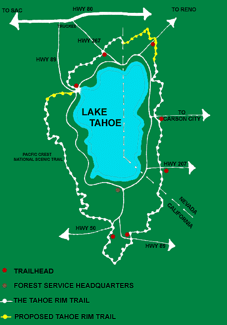
The Tahoe Rim Trail is one of the world's premier
trails and is marketed as a 165 mile loop trail. In reality, it is longer
and for thru-hikers, you must include road sections. So, for planning
purposes, the total mileage is closer to 164 miles.
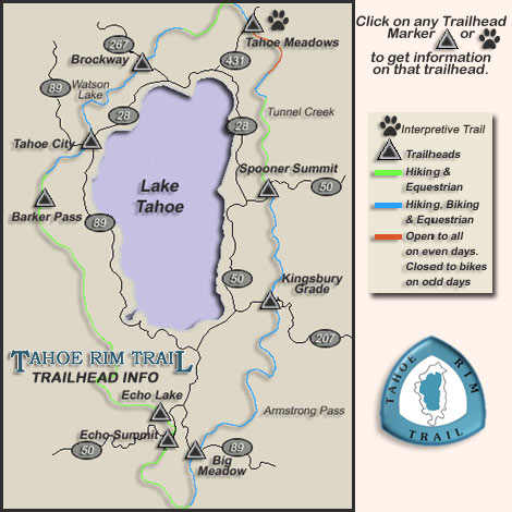
It is a trail that offers something for everyone. Hiking,
horseback riding and skiing are allowed on all portions of
the trail. Mountain biking is allowed on the trail with the exception
of the wilderness areas, the section that is in Lake Tahoe, Nevada State
Park and the the part that is in conjunction with the Pacific Crest Trail.
We have provided a very simple map to give you a general idea but we would
highly encourage you to order the more detailed map from the Tahoe
Rim Trail Store. It is detailed enough to allow you to
plan a safe adventure on the trail. In addition if you have been
hiking the TRT Association would appreciate feedback
on the condition of the trail so that we can schedule maintenance if
necessary. Be sure to check out the volunteer
opportunities that are available. Going on one of our backcountry
work camps can be a great way to have a great vacation while giving
back something to the TRTA. |
The Tahoe Rim Trail is a backcountry, non-motorized scenic trail. Please
enjoy your travels, but leave no trace that you were there! This means low
impact camping, pack out your trash, take only pictures. The Tahoe Rim
Trail is marked with triangular light blue trail markers with the words
"Tahoe Rim Trail" stamped on them. The markers are spaced
periodically along the trail as confidence markers and at major trail
junctions and road crossings. It is typical to travel several miles
between markers. The signs do not always last through each season, so
always be prepared with a map and compass.
When is the best time to hike:
The Tahoe Rim Trail is open when the snow has melted off the trail in
the summer - usually mid-June and until the snow starts in the fall -
usually late October. The best times to hike are early to mid-July for
wildflowers and September/October for fall colors. During the winter
months, the amount of snow that falls in the Sierra obscures the trail. If
you are planning winter travel, you must be prepared for extreme weather
and be competent with GPS and quadmaps.
It's a Loop, Where do I start:
If you are planning to hike the entire TRT loop, where you start can be
important for planning food & water caches, campsites, and where you
park your vehicle, if you drove.
Distance:
The trail is marketed as a 165 mile loop trail. In reality, it is
longer and for thru-hikers, you must include road sections. So, for
planning purposes, the total mileage is closer to 164 miles.
Starting:
• We recommend you take a taxi or have someone drop you off
at a trailhead. This will alleviate parking at a trailhead for an extended
period of time.
• If you do drive, you can park at any of the following Tahoe Rim
Trail trailheads:
Brockway East (off of Forest Service Rd 16N56), Tahoe Meadows Trailhead
(Hwy 431), Spooner Summit (North or South), Kingsbury Grade (North or
South), Big Meadow Trailhead (Hwy 89), Echo Summit sno-park (Hwy 50 at the
summit), Echo Lakes (upper parking lot), or Barker Pass (Forest Service Rd
15N38).
Parking:
• Make sure your vehicle is in a designated parking
area.
• Parking in these areas is at your own risk.
Neither the TRTA nor the US Forest Service is responsible for your
automobile. Please do not leave any valuable items, wallets, etc. in your
auto.
Tahoe City South (at the Truckee River Recreation & River Access
Parking Lot) has a 72-hour parking ordinance. If you need to park here for
over 72 hours, contact the Tahoe Rim Trail office to register your car.
Wilderness Permits and Reservations:
• You will need a permit to enter the Desolation
Wilderness (5. Echo Lakes to Barker Pass section). In 1978, the
Forest Service began a quota system in which they limit the number of
overnight users from the Friday before Memorial Day through September 30
of each year. You must enter on the date specified on your permit and must
spend your first night in the zone which you have chosen. The rest of your
stay is not subject to zone requirements. Have some alternative zones in
mind in the event those zones are not available. During the
quota season, 50% of the quota in each zone may be reserved in advance.
The other 50% of the available quota is set-aside for first-come,
first-served visitors. These permits must be obtained in person at offices
that issue Desolation Wilderness permits and may not be reserved ahead of
time. Overnight permits may be reserved by phone, mail, or fax in
advance but must be picked up in person. The point is, you will need to
get your permit prior to your hike.
Click here for complete trail information ....
|
| TAHOE
MEADOWS INTERPRETIVE TRAIL
This 1.3 mile loop
trail winds among huge granite boulders and towering
pines, crosses sparkling mountain streams, and wanders through a lush
alpine
meadow. The entire loop is wheelchair accessible.
Trailhead
Tahoe Meadows: 1/2 mile southwest of Mt Rose summit on Hwy 431. Paved
parking, vault toilets. Trail begins at lower parking lot. Look for sign
for INTERPRETIVE TRAIL. The trail is open by mid-July until the first
snowfall in the fall (usually October).
**Bikes
and horses are not allowed. This interpretive trail is designed to
be a safe, comfortable experience for people of all ages and people in
wheelchairs. |
| Dogs
on the Tahoe Rim Trail
Regulations for dogs
on the Tahoe Rim Trail:
Nevada State Park -
dogs are allowed on the Tahoe Rim Trail in Nevada State Park. They must be
under voice command control or on a leash.
National
Forest:
Dog restrictions are regulated by each county. However the US Forest
Service does not enforce county regulations. The US Forest Service
requires that dogs must be under owner control. Dog owner will be cited if
the dog is harassing wildlife or has bitten or injured a human.
Remember to pack
extra water and even a snack for your dog when they accompany you on a
hike or ride.
If you would like to
check with the counties on the specific county ordinance, please contact
them yourself:
El Dorado County 530-577-1766
Placer County 530-546-4260
Washoe County 775-832-4107
Carson City 775-887-2171
Douglas County 775-782-9935
Alpine County 530-694-2231
|
URL: http://www.tahoesbest.com/Hiking/trailsbyregion.htm
|